


Roche Plate Maïdo

ramagufa
User
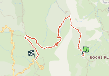

Length
5.8 km

Max alt
2170 m

Uphill gradient
1138 m
Km-Effort
17.5 km

Min alt
1088 m

Downhill gradient
77 m
Boucle
No
Creation date :
2023-01-12 17:43:20.907
Updated on :
2023-05-20 19:01:13.741
3h58
Difficulty : Difficult

FREE GPS app for hiking
 SityTrail
IGN / Geographical institutes
SityTrail Plus
The world is yours!
About
Trail Walking of 5.8 km to be discovered at Réunion, Unknown, La Possession. This trail is proposed by ramagufa.
Description
A visionner sur OpenstreetMap
Deuxième jour de rando depuis la canalisation des Orangers, Roche PLate La Brèche, MaÏdo
Positioning
Country:
France
Region :
Réunion
Department/Province :
Unknown
Municipality :
La Possession
Location:
Unknown
Start:(Dec)
Start:(UTM)
333613 ; 7669418 (40K) S.
Comments